Kaumalapau Harbor is located on the southwest coast of the island of Lanai. Lanai is the sixth largest island in the State, covering about 140 square miles with about two percent of the state’s land area. The island has about 3,400 full time residents, most living in or around the island’s only town, Lanai City. Larry Ellison, co-founder of Orable Corporation, owns 98% of the island.
Kaumalapau Harbor was constructed in 1925 by the Hawaiian Pineapple Company (Dole Company) for the export of pineapple, the island’s primary product and business up until the early 1990s. The harbor is located in a small embayment providing a 10-acre berthing area with water depths of 20 to 60 feet. The harbor is protected by a breakwater constructed in 2008 using concrete Core-Loc armor units. Shoreside facilities on the north side of the embayment in the lee of the breakwater include a 400-foot-long wharf, sheds, and barge loading and unloading equipment.
In the early 1990s, the growing of pineapple was terminated, two luxury resort hotels were built, and the island changed from an agricultural economy to an economy based on tourism. Primary use of the harbor changed from the export of pineapple to the import of fuel and goods to support the new economic base industry. Ownership of the harbor was transferred to the State of Hawaii in July 2000. The State Department of Transportation, Harbors Division, now operates the harbor as part of the statewide harbor system.
Kaumalapau Harbor is Lanai’s only commercial harbor, and is essential to the welfare of the island’s residents and visitors. There are no other harbors or safe landings on the island capable of accommodating the tug and barge services which bring virtually all the consumer goods and all the fuel for the island. The hotel and related development on the island are anticipated to increase the resident population, and the increase in visitors to the island also adds to the population base.
Problem
Young Brothers (YB) was scheduled to offload the island’s weekly cargo on the morning of June 19, 2024. Extreme high and low tides were occurring in Hawaii as a result of the summer solstice. YB’s barge had a draft of 15 ft and had previously successfully navigated through the harbor, which has a design depth of 27 feet at the pier. On that day, however, low tide was less than 0, and the barge was reportedly hitting bottom in the harbor. YB personnel determined that it was unsafe to offload the cargo and returned to deeper water.
YB notified the Kaumalapau Harbor agent of the situation. Within hours, the Department of Transportation (HDOT) had contacted Sea Engineering requesting a multibeam bathymetric survey of Kaumalapau Harbor to help determine the reason for the vessel grounding.
Response
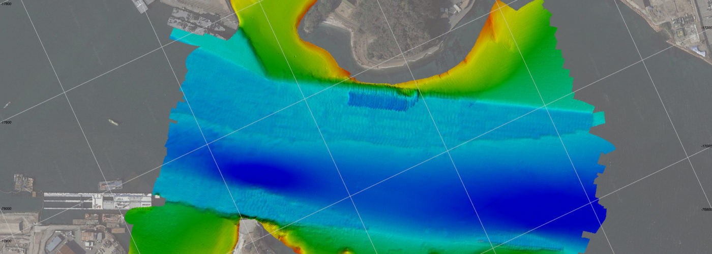
Sea Engineering submitted a proposal for a multibeam bathymetric survey of Kaumalapau Harbor the next day. A multibeam bathymetric survey quickly produces a dataset of georeferenced soundings at horizontal resolution of less than one inch. Sea Engineering’s equipment was rerouted to Lanai, and quick proposal turnaround and NTP from HDOT resulted in Sea Engineering’s response by scheduling the survey.
Technology
Multibeam Survey Method
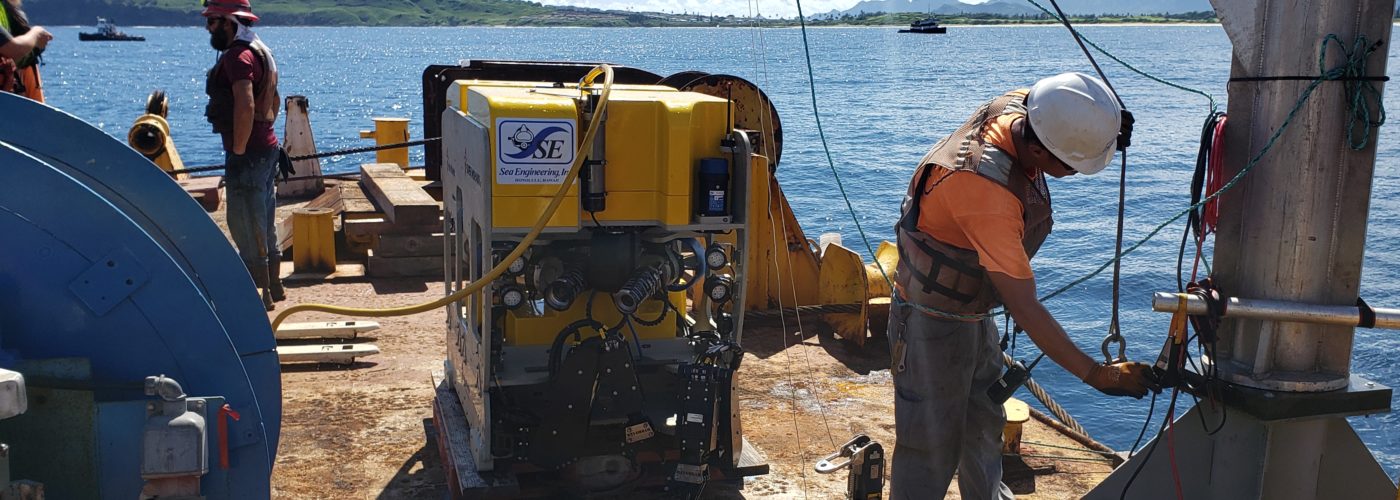
The multibeam sonar system (MBES) for this project is an R2 Sonic 2020, which generates a swath of 256 beams, with a user variable swath width from 10° to 130°. The operating frequency is selectable from 200 to 700 kHz with a beam width of 1 to 4 degrees depending on frequency. The harbor basin and channel were surveyed with a frequency of 400 KHz. The sonar system employs a specialized mount to securely attach the sonar head and inertial navigation system (INS) to the side of the survey vessel, with the sonar in a vertical configuration and the center (nadir) beam oriented straight down.
Standard hydrographic surveying methodology was followed during the survey, as provided in the U.S. Army Corps of Engineers EM 1110-2-1003, dated November 30, 2013. Quality control procedures for multibeam systems include:
- Survey documentation
- Multibeam patch tests
- Vertical position check at project vertical benchmarks, tide level check, and RTK tide data collection
- Horizontal position check at project benchmarks
- Velocity cast measurements
LiDAR Survey Method
A Velodyne VLP-16 LiDAR sensor was attached to the sonar mount pole directly above the SONAR head. The sensor is approximately 3.75 inches in diameter, 3 inches in height, and has 16 lasers capable of firing 18,000 times per second each.
The LiDAR data was collected by the data acquisition software simultaneous with the multibeam data, and was therefore paired with the same inertial navigation data for precise laser geo-rectification. Calibration of the LiDAR was conducted by surveying a fixed object from multiple directions. A performance check was conducted by comparing the LiDAR data with overlapping topographic data.
The real-time simultaneous pairing of the underwater multibeam sonar data with the land LiDAR data was a very successful integration of two modern, high-technology survey systems. While substantial time is usually spent integrating different datasets into a single survey, the on-the-fly meshing of the multibeam and LiDAR data into a single, georeferenced point cloud dataset reduced post-processing time by more than 90%. As a result, Sea Engineering was able to provide the client with samples of the point cloud less than 24 hours after completion of the survey. This level of responsiveness can rarely be achieved, and was made possible by the hard work and dedication of our field team that can mobilize and perform surveys on a moment’s notice.