Overview
Hilo Harbor is one of only two commercial ports serving the Island of Hawaii and the primary hub for maritime traffic on its eastern side. Handling over 2 million tons of cargo annually, it plays a vital role as the island’s major distribution center. The harbor offers extensive maritime facilities and services and is home to the only pier on the island capable of accommodating cruise ships.
The original breakwater, completed in 1930, spans 10,080 feet as a rubble-mound structure built over Blonde Reef, protecting a 35-foot-deep basin. Over the years, the breakwater has sustained repeated damage and undergone numerous repairs. Further damage could jeopardize the harbor’s functionality, highlighting the need for ongoing maintenance and protection efforts.
Climate Change Preparedness and Resilience
The U.S. Army Corps of Engineers (USACE) is dedicated to mitigating vulnerabilities in the United States’ waterfront and coastal infrastructure caused by climate change and variability. This commitment includes designing resilient systems and adapting existing assets to ensure their continued functionality.
To maintain the stability and performance of navigation structures in a changing climate, engineers must shift from the traditional assumption of stationarity—that future conditions will mirror the past—to a forward-looking approach that explicitly considers the dynamic impacts of climate change and rising sea levels.
Resilient Repairs for Hilo Harbor Breakwater
The USACE Honolulu District plans to undertake repairs to the Hilo Harbor breakwater within the next decade. In alignment with the USACE’s commitment to resilient and adaptive designs, Sea Engineering conducted a comprehensive analysis to optimize future repairs by incorporating risk of failure and reliability-based design under projected future conditions.
This multifaceted effort included:
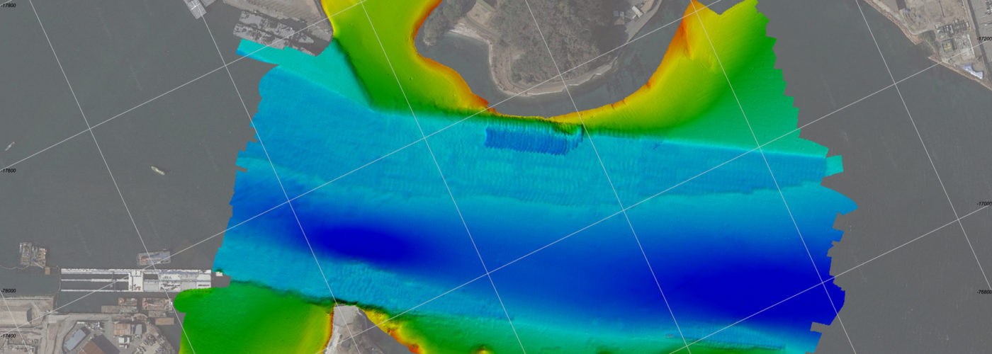
- Assessment of existing damage using visual inspections and high-resolution lidar topographic data.
- Analysis of structural instability and overtopping rates, both present and future, under extreme wave climates and rising sea levels, utilizing advanced modeling techniques such as spectral phase-averaged wave modeling, Boussinesq phase-resolving models, and high-fidelity, fully three-dimensional Computational Fluid Dynamics (CFD) wave modeling.
- Reliability-based design evaluations to analyze past and current performance, identifying key damage modes.
- Development of conceptual repair designs that enhance resilience, focusing on stability and performance under future sea level rise scenarios.
This approach ensures the breakwater will be better equipped to withstand the challenges of a changing climate while maintaining its critical role in supporting harbor operations.
Innovative Unified Repair Design Analysis Approach
This project introduced a novel approach to unify the design analysis process into a cohesive, fully numerical framework. The methodology begins with global-scale wave generation and telescopes incrementally down to detailed Computational Fluid Dynamics (CFD) simulations of individual armor units at the project site. Boundary condition data seamlessly transitions between modeling levels through direct nesting or output boundary conditions, eliminating the need for empirical assumptions.
The CFD model domains were constructed using high-resolution LiDAR topography and bathymetry data to create an accurate virtual reconstruction of the breakwater corridor. Three-dimensional wave overtopping simulations at high levels of detail were driven by wave height and velocity time series generated from preceding phase-resolving 2D wave models. The results revealed that wave overtopping heights increase with rising sea levels, peaking at an average of 1.4 meters (4.6 feet) above the breakwater crest elevation under a projected sea level rise of 0.91 meters (3 feet).
One of the key strengths of CFD simulations is their ability to provide highly detailed visualizations of hydrodynamic processes. This capability greatly enhances the understanding of flow fields and the interactions between water and structure. To leverage this, an additional series of ultra-detailed CFD models—featuring nearfield domains with millimeter-scale mesh cell sizes—was developed. These models were used to analyze the hydrodynamic effects of wave overtopping on the stability of breakwater armor stones.
Laser-scanned boulders were scaled and incorporated into a three-dimensional CAD reconstruction of the breakwater, achieving millimeter-level accuracy. This virtual facsimile included detailed representations of individual armor units and their interstitial voids, resulting in a quasi-porous model. This high-fidelity approach provided valuable insights into the structural and hydrodynamic behavior of the breakwater under extreme conditions.
Damage and Reliability
Visualizations from the nearfield CFD analysis revealed a highly energetic and turbulent flow region forming directly behind the breakwater during significant wave overtopping events. This high-energy area, located on the harbor side of the breakwater, exhibited potential for backward-progressing erosion of the unconsolidated seafloor material.
The analysis also identified two critical zones where armor unit stability may be compromised: the seaward toe and the harbor-side row of crest stones. Model results showed that wave forces, amplified by rising sea levels, could lead to incipient destabilization of some armor units in high-risk areas with as little as 0.18 meters (0.6 feet) of sea level rise under 50-year design conditions.
Integrating CFD modeling into the design process provided a fully numerical framework for assessing breakwater stability under far-field wave conditions. This approach minimized human subjectivity, ensuring a consistent and objective evaluation from start to finish.
The CFD modeling results for both current and projected future conditions were used to establish zones of expected damage along the breakwater, based on USACE-defined criteria. These zones were instrumental in delineating the extents of future repair areas and informing repair concepts tailored to the structure’s resilience needs.
Looking to the Future
The allocation of limited federal maintenance funds for aging navigation structures nationwide must be carefully prioritized, as these structures face increasing exposure to larger storm waves driven by accelerating climate change and intensifying storm activity. Strategic repairs and adaptive designs will be essential to ensure their long-term resilience.
This project provides a valuable road map, showcasing the use of advanced analytical tools and methodologies to inform such efforts. The insights gained and lessons learned from this project offer broader applicability, serving as a guide to enhance the resilience of coastal structures in the face of future climate challenges.